Thu 19 Jun
Mulhacén, Sierra Nevada
Ascent: album
As the bus wound its way up, Salobreña was visible from time to time, 60km away, a white speck on the coast. This did not surprise me all that much, as I figured that, since you can see Mulhacén from my house, you ought to be able to see my house - or at least, my town - from Mulhacén. Up until around 2000m, the road passed through high meadowland and wooded slopes, with occasional clusters of flowers creating teasing spots of colour that set my shutter finger twitching. Fernando, the guide, pointed out what he claimed were the highest bee-hives in Europe ... well, as he said, why not?
We got out at Alto del Chorrillo, and walked across to look almost vertically down the gorge over Trevélez, the village that claims to be the highest in Spain - well, why not? - and which is the home of some of the finest Iberian ham. A mouthwatering start to the day.

Trevélez, from Alto del Chorrillo
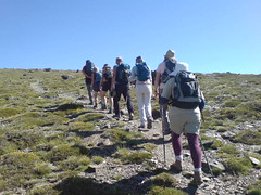
As we started walking up the views were ever-varied, and breathtaking. As I usually do, I paused from time to time to take photos - a mountain vista here, a tiny flower there.

Gentian and Saxifrage, peeking out
However I soon had to ration my stops, as I found the main body of the group quickly moving off into the distance; these were experienced walkers, and mostly a good deal younger than me, and I needed to keep going.
I soon found that talking while you walked was not an option, either; I had only flown in from the UK the day before, and the air that felt fresh and invigorating was, at approaching 3000m, considerably thinner than I was accustomed to.
Every now and then Fernando stopped to point out a view, or a rock formation, or a plant, or a bird. After an hour we stopped for a few minutes, for a drink and a brief rest, and an hour or so later Fernando decreed a food break.

Refuelling
Above 3000m I found myself struggling to keep up. I was beginning to lose touch with the rest of the group, and now and then losing track of the path; although the way is marked with little cairns, the mountainside is nothing but loose rock, and I sometimes found it difficult to distinguish the markers from the scree. Several times I found myself scrambling over the rocks until I came across the path again.

Where's the path?
Mulhacén and back: background - ascent - at the top - descent - been there, done that
Bloglets: full moon - single file - pause - at the top - back in Salobreña
Bloglets: full moon - single file - pause - at the top - back in Salobreña
No comments:
Post a Comment