Showing posts with label Sierra Nevada. Show all posts
Showing posts with label Sierra Nevada. Show all posts
Monday, 5 January 2009
Sierra Nevada
Powered by Google Earth Hacks | Map Details | Create your own!
ShareIt from Google Earth Hacks lets you choose a location and show it in GE in a blog. Seeing as how it's GE it should allow you to explore to your heart's content. Try tilting to see the mountains in profile; or fly North to Granada, South to the Alpujarra villages, the Contraviesa range, and the coast.
Wednesday, 23 July 2008
Mulhacén and back 5: been there, done that
 Thu 19 / Fri 20 Jun
Capileira, Sierra Nevada
That evening in Capileira I had a delicious lamb cous-cous at the wonderful little Ibero restaurant. It was a bit of a struggle climbing back up through the village to the hostal afterwards, but hey, what’s 5 minutes when you’ve just walked up Mulhacén and back?
The following morning I picked up all the things the well-prepared mountain walker would have taken up with him in the first place - a detailed map, a guide book, a plant book - and a couple of collapsable sticks.
And then on the way out I stopped off in Pampaneira, at the Sierra Nevada Information Centre, where I got my final memento:
Cumbres de Sierra Nevada
Peaks of Sierra Nevada
En la montaña, por tu seguridad ¡déjate guiar!
In the mountains, for your own safety, go with a guide!
Other accounts
Jari Kirvesoja
Mulhacén and back: background - ascent - at the top - descent - been there, done that
Bloglets: full moon - single file - pause - at the top - back in Salobreña
Bloglets: full moon - single file - pause - at the top - back in Salobreña
Mulhacén and back 4: descent
 Thu 19 Jun
Mulhacén, Sierra Nevada
Descent: album
Coming down was harder than going up, largely because by that time my legs already had the going up in them. Fernando took us down via the incredibly steep Loma del Mulhacén. I hobbled down the first bit, doing my best to concentrate on admiring the view.

Admiring the view
However halfway down my legs gave up completely, stiff with cramp. Everyone gathered round and I was offered all sorts of physical treatment from stretching, which helped but not enough, to massage, which was tempting and which perhaps I should have accepted.
Fernando gave me some salt tablets, which I think was the key; you are conscious of being thirsty and needing to take on water, but you don’t realise how much you are perspiring, and as the sweat evaporates, with it of course goes your body’s salt supply.
One of the Explorers kindly lent me one of her walking sticks - she insisted she didn’t need two, though I was sure she had been using both of them on the way down. The stick was a tremendous help on the rest of the steep descent, enabling me to get to the bottom of the slope without cramping up again (well, almost).
Part way down we paused to look at the North Face from below, at close quarters. Most impressive. Surely people don’t climb that for fun?

North Face of Mulhacén
Below it is a small lake, La Laguna de la Mosca (Lagoon of the Fly), which I imagine feeds one or other of the rivers that flow through the city of Granada.

Laguna de la Mosca
Strange to think that, on this northern side, the snow melt we were looking down on would eventually make its way across southern Spain - via the river Guadalquivir - to drain into the Atlantic, whilst the little lagoons we were heading down towards on the southern slope were making a beeline for the Mediterranean.

Southern lagoons
Once we got down to the lagoons we were on a track that more or less followed the contours back to the bus, and my legs began to feel as though they belonged to me again.
I am eternally grateful to Nevadensis - especially Fernando - for enabling me to do this walk, and to the people on the Explore trip and their guide Conal for accepting me into their group for the day, and helping me get through it. I’ve been wanting to do it for over 40 years, and if I were to leave it for another two or three years I probably wouldn’t be able to make it at all.
Although I do have some unfinished business up there - there’s all those flowers I didn’t manage to snap, and that final top rock I didn’t get up to . . .
Mulhacén and back: background - ascent - at the top - descent - been there, done that
Bloglets: full moon - single file - pause - at the top - back in Salobreña
Bloglets: full moon - single file - pause - at the top - back in Salobreña
Mulhacén and back 3: at the top
Thu 19 Jun
Mulhacén, Sierra Nevada
At the top: album
By the time I got to the top - ¡olé! - my legs were reluctant to do things you normally take for granted, like move, or support my weight. So I sat down and tried to massage and flex my muscles, and take in the view, and the achievement. And had half my cheese bocadillo, and half my water.
The views from the top are truly breathtaking, and different in each direction. The North Face is a sheer cliff, which funnels into a shallow glacial cirque, with a steep-sided V-shaped valley heading off to the north-west towards Granada and its Vega.

Looking down on Granada
This cliff curves round to the west, where it gives way to a long narrow ridge leading to the Veleta peak.

Towards Veleta
To the east there is a succession of rounded peaks separated by the major Alpujarra valleys, and to the south a much gentler incline leads back down to the Upper Poqueira Valley - this is the route we had come up by.

Towards the Alpujarra
I would have loved to have joined those who climbed up the last rocks, to get to the highest point, but there is no way I could have got up there. So I contented myself with taking a few photos, and sending one or two from my mobile phone to Flickr and to this blog; there is 100% coverage at the top, and most of the way up, which is reassuring.
Mulhacén and back: background - ascent - at the top - descent - been there, done that
Bloglets: full moon - single file - pause - at the top - back in Salobreña
Mulhacén and back 2: ascent
Thu 19 Jun
Mulhacén, Sierra Nevada
Ascent: album
As the bus wound its way up, Salobreña was visible from time to time, 60km away, a white speck on the coast. This did not surprise me all that much, as I figured that, since you can see Mulhacén from my house, you ought to be able to see my house - or at least, my town - from Mulhacén. Up until around 2000m, the road passed through high meadowland and wooded slopes, with occasional clusters of flowers creating teasing spots of colour that set my shutter finger twitching. Fernando, the guide, pointed out what he claimed were the highest bee-hives in Europe ... well, as he said, why not?
We got out at Alto del Chorrillo, and walked across to look almost vertically down the gorge over Trevélez, the village that claims to be the highest in Spain - well, why not? - and which is the home of some of the finest Iberian ham. A mouthwatering start to the day.

Trevélez, from Alto del Chorrillo
As we started walking up the views were ever-varied, and breathtaking. As I usually do, I paused from time to time to take photos - a mountain vista here, a tiny flower there.

Gentian and Saxifrage, peeking out
However I soon had to ration my stops, as I found the main body of the group quickly moving off into the distance; these were experienced walkers, and mostly a good deal younger than me, and I needed to keep going.
I soon found that talking while you walked was not an option, either; I had only flown in from the UK the day before, and the air that felt fresh and invigorating was, at approaching 3000m, considerably thinner than I was accustomed to.
Every now and then Fernando stopped to point out a view, or a rock formation, or a plant, or a bird. After an hour we stopped for a few minutes, for a drink and a brief rest, and an hour or so later Fernando decreed a food break.

Refuelling
Above 3000m I found myself struggling to keep up. I was beginning to lose touch with the rest of the group, and now and then losing track of the path; although the way is marked with little cairns, the mountainside is nothing but loose rock, and I sometimes found it difficult to distinguish the markers from the scree. Several times I found myself scrambling over the rocks until I came across the path again.

Where's the path?
Mulhacén and back: background - ascent - at the top - descent - been there, done that
Bloglets: full moon - single file - pause - at the top - back in Salobreña
Bloglets: full moon - single file - pause - at the top - back in Salobreña
Tuesday, 22 July 2008
Mulhacén and back 1: background
Thu 19 Jun
Mulhacén, Sierra Nevada
[If you see this account before I've managed to add in all the photo and other links, please come back a week or two later]
Mulhacén (3482m) is the highest peak of the Sierra Nevada, and the highest in continental Spain (Teide, in Tenerife, Canary Islands, is a bit higher).
Powered by Google Earth Hacks | Map Details | Create your own!
NB: If this doesn't display, you may need to download and install the Google Earth plug-in.
The Sierra Nevada (map, satellite photo) runs west-to-east across Andalucía, and its peaks are visible from well over 100km away on all sides. On the northern side, the major peaks provide a snow-topped backdrop to the city of Granada throughout much of the year
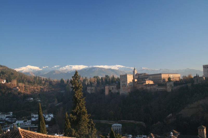
Backdrop to Granada
- whilst to the south they are also visible from many points along the coast.
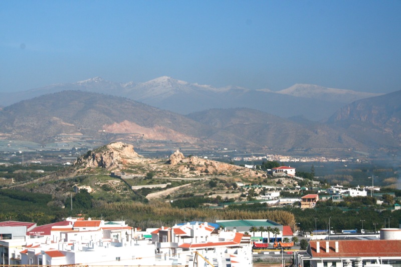
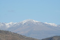
Mulhacén from Salobreña
Twenty years ago you could drive your own car up to the top of nearby Veleta, and down the other side, although the higher roads were unsurfaced, and it wasn’t exactly encouraged. Nowadays, quite rightly, the whole area is a protected National Park, and private vehicles are not allowed in.

Veleta, from halfway up Mulhacén
There are several ways to get up Mulhacén: you can walk, you can walk, or you can walk, and if you're really daft you could try scaling the North Face.

Fancy scaling the North Face of Mulhacén?
Some do it as part of a longer trek across the Sierra Nevada, over two or more days, camping out or staying in unattended mountain refuges; most go up as I did on a one-day excursion from the southern side, taking a bus part-way up, to Alto del Chorrillo (2600m), some way into the National Park, and walking the rest.
Another possibility is to drive your own car up to the entrance to the National Park, and walk from there; this gives you several hours’ more walking to get up to the top and back, although you are not then tied to the bus timetable.
The buses run from the three Poqueira Valley villages (pic) - Pampaneira, Bubión and Capileira, which is the highest at 1400m. If you just want to take the bus to Alto del Chorrillo, as several people did the day I went, at 7.50€ return the fare compares well with travelling one stop on the London Tube.
The buses are run by Nevadensis, a tour company specialising in all types of Sierra Nevada trip. My excursion cost 40€, which covered the bus and the 6-hour guided walk. Their guides are superb: highly experienced, well-qualified, and very helpful. I had good cause to be thankful for this.
I stayed overnight in Capileira, at the comfortable and inexpensive Hostal Carril (aka Paco López, aka El Cascapeñas), and joined the bus at 8.30 the following morning.
The group I went up with were coming to the end of a 10-day walking holiday with the tour company Explore, and during the previous week they had already been up to one of the other high peaks as well as doing a number of other walks, including some that I had done on previous visits to the area, such as up the Poqueira Valley (pic), and round the Tahá villages (pic) - all highly recommended.
Mulhacén and back: background - ascent - at the top - descent - been there, done that
Bloglets: full moon - single file - pause - at the top - back in Salobreña
Bloglets: full moon - single file - pause - at the top - back in Salobreña
Friday, 20 June 2008
Back in Salobreña
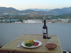
Back in Salobreña, dinner up on the roof. Watching swifts and swallows - sorry none in the picture, they won't stand still.
Mulhacén in the background - the middle of the three peaks on the sky-line. I was up there yesterday!
Thursday, 19 June 2008
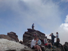
At the top
Made it! Somehow. One of the Explore group stands on top of the world, or at least, on top of continental Spain. And yes, that is snow on the left. This is the Sierra Nevada, after all.
Technical note
These bloglets posted on Thu 19 Jun were originally pictures taken on my mobile phone, and sent from Mulhacén to Flickr and on to here - including this one, from the summit. One more bit of magic! It's now Sat 21 Jun, and I'm back in Salobreña with a broadband connection, so I'm able to edit a bit and add these commentaries - I couldn't see how to do it from the mobile.
There are lots more photos, from my Canon and from the mobile;
I'll also add more to this blog; you'll be able to get to the whole story via this Mulhacén link.
Pause on way up
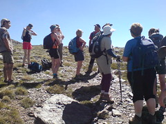
One of several. From here on I found I couldn't walk and talk at the same time - I didn't even try chewing gum - and eventually fell further and further behind the group. On the final stretch I kept losing sight of the next person round a bend or behind a rock, and then couldn't locate the path so I ended up scrambling over rocks until I found it again. So there's no photos of that bit - I was too busy not getting lost. By the time I got to the top - ¡olé! - I had cramp in both legs.
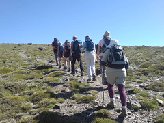
Single file up Mulhacén
The Explore group start the climb. Uphill all the way, from 2600m to 3400m. No wonder I felt light-headed and heavy-legged by the time I got to the top. And that was before I tried getting down again!
Wednesday, 18 June 2008
Full moon in Capileira :) xxx
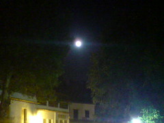
Full moon in Capileira. The bus sets off from here tomorrow morning for the walk up Mulhacén. Is this a sign?
Subscribe to:
Posts (Atom)